Monitoring afforestation projects
In order to truly quantify the impact of afforestation on carbon capture, best anticipate credits for our landowners and ensure we’re driving a high level of quality in our projects, Arbonics actively monitors and reports on all of its project sites across Europe.
Monitoring includes:
- Understanding the timing of activity, such as the timing of land preparation, planting, thinning/harvesting events, etc.
- Understanding how land has been prepared, including any deep soil disturbance or biomass removal on the site
- Ensuring that any permits or approvals for planting have been obtained, such as permissions to plant on Natura 2000 land
- Tracking what has been planted, when, and the exact area of the planting
- Tracking increases in biomass on the site from tree growth, or any biomass losses due to cutting, pests, fires, etc.
- Measuring increases in soil organic carbon
- Ensuring that land has been legally converted to registered forest after planting
- Monitoring any changes in land boundaries, ownership, land use, etc.
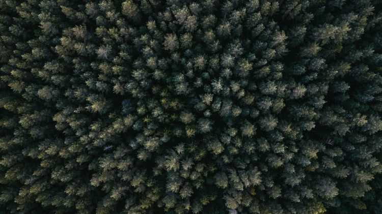
To gather this data, Arbonics uses a combination of advanced tools. Remote sensing technology—which involves using satellites and aerial tools like LiDAR to monitor land from above—allows us to detect changes on the ground and accurately measure biomass without needing to visit every site in person.
We also draw on national land and forest registries, and supplement this with on-site photos and measurements either coordinated by Arbonics or provided directly by the landowner. In some cases, we may also request supporting documents or confirmations from the landowner.
The results of our monitoring are shared with key stakeholders. Verification agencies such as Verra rely on this data during credit issuance events. This independent verification is what enables landowners to earn certified carbon credits, which can then be sold to generate income. Credit buyers depend on transparent reporting to assess the quality and credibility of their investments. And landowners gain insight into the performance of their forest from a carbon capture perspective—helping them understand how this translates into credit income.
We take care of most of the monitoring and reporting, but landowners play an important role at key points throughout the process. In many cases, the details, such as tree species and age, are already part of standard forest management practices. This document outlines what to expect and where your input may be needed.
Monitoring process
Afforestation projects involve an initial monitoring phase to establish baseline conditions, followed by ongoing monitoring throughout the project’s duration.
1. Initial monitoring and site preparation
Before planting begins, Arbonics will measure and record data to calculate carbon storage potential and ensure project requirements are met.
Landowner must confirm:
- Date land preparation started (beginning of the crediting period)
- The pre-project use and state of the land
- How the soil was prepared
- Whether soil was ‘deeply disturbed’ (defined as > 25cm deep)
- Confirmation of any biomass removal (e.g., clearing shrubs) and whether it remained on-site, as required by regulations
To ensure accuracy, Arbonics uses remote sensing to obtain a biomass reading for the project area at the start of the crediting period (t0). We also gather biomass estimates for t-5 and t-10 years to verify that no pre-project clearing or other biomass removal occurred prior to project registration.
If soil preparation involves disturbance deeper than 25cm, project regulations require professional soil sampling before and after preparation to calculate potential carbon loss. This process is often costly and time-consuming, and may significantly reduce the number of credits the site is eligible to generate. As such, we strongly advise against these types of soil preparation methods.
While Arbonics can assist by referring testing providers, the responsibility and cost of soil sampling, analysis, and documentation remain with the landowner.
2. Planting and project launch
When the landowner completes planting activities, we ask them to confirm:
- Exact year of planting activities
- Exact planted area
- Species mix and age of seedlings
- Density of planting (trees per hectare)
While carbon credits are based on actual biomass growth, collecting this data helps predict forest development and estimate the timing and amount of future credit issuances.
3. Ongoing monitoring
As the forest grows, we gather regular measurements via integrated remote sensing, such as tree growth, biomass accumulation and land use changes.
This data is automatically collected, meaning most landowners won’t need to take additional action unless a significant change is detected. If unusual biomass loss is recorded, we’ll reach out to investigate.
4. Credit issuance
Carbon credits are issued based on the amount of carbon captured over time. To verify this, Arbonics organises an independent audit with our verifiers, Verra, every 3-5 years. This verification will:
- Quantify the carbon captured by each project site in the time period
- Quantify the change in the ‘baseline’ carbon captured
- Identify and report on any loss events in the time period
- Investigate whether any ‘leakage’ has occurred due to project activities
Want to understand the credit calculation process in more detail? We’ve created a step-by-step guide explaining how credits are calculated. If you'd like a copy, just reach out to us at hello@arbonics.com.
Once verification is complete, auditors submit findings to Verra, which reviews and approves the issuance of carbon credits. Arbonics will manage all of this process and maintain direct communication with the landowner throughout the event, which typically takes 9-18 months and follows three key phases:
- Submission preparation – gathering final measurements and calculating total carbon impact
- Independent audit – third-party Verra auditors assess the submission and credit request
- Final approval – Verra confirms the findings and issues carbon credits
Landowner responsibilities
Arbonics manages the majority of the verification process—including data from the preparation and planting stage, any recorded loss events, and biomass measurements—as well as continuous remote sensing for biomass tracking. In most cases, no additional effort is required from the landowner.
However, in some cases landowners may need to support the verification process:
- A subset of ‘monitoring plots’ will be selected for on-site monitoring to cross-reference the remote sensing data, requiring landowners to provide tree height, diameter, and biomass readings for selected areas (you may already track this data as part of routine forest management)
- If deep soil disturbance was recorded at the start of the project, soil samples taken by landowners may be required to assess changes in soil organic carbon
- Auditors may request site visits to verify calculations or investigate any anomalies. Arbonics will coordinate these visits and keep landowners informed throughout the process
Loss events and reporting
Forests can face challenges, from natural disasters to pests or failed plantings. While Arbonics detects biomass reductions through remote sensing, landowners should report any major loss events as soon as possible. This will allow us to take any actions needed and quantify the impact to carbon capture.
As part of our verification responsibilities, we must report these events to Verra. If this happens, we may need some details from the landowner to complete the report.
Cost of monitoring
Arbonics covers the costs of:
- Remote sensing data subscriptions integrated into Arbonics technology
- External expert costs for calculating and submitting verification results
- On-site measurements for Arbonics' selected monitoring plots
- Independent auditor fees for each verification event
- Verra’s verification event fees
Landowners will be responsible for obtaining:
- Permits, approvals, or documentation for planting or verification e.g. protected land permissions
- Additional tests requested by Verra or auditors to investigate an abnormality or outstanding questions
- Soil organic carbon tests if deep soil disturbance occurs during site preparation
- Damage assessments after loss events to determine and report on damage and carbon loss
- Land use changes and forest registry updates
Information sharing
Landowners can report forest changes and provide required updates through:
- Our Landowner Portal technology (coming soon), where landowners can manage all aspects of their project with Arbonics, and
- Through our Customer Impact Team, at landowners@arbonics.com ready to support you and ensure a smooth process for your afforestation project
By working together, we can ensure that the entire process runs smoothly from planting to credit issuance.